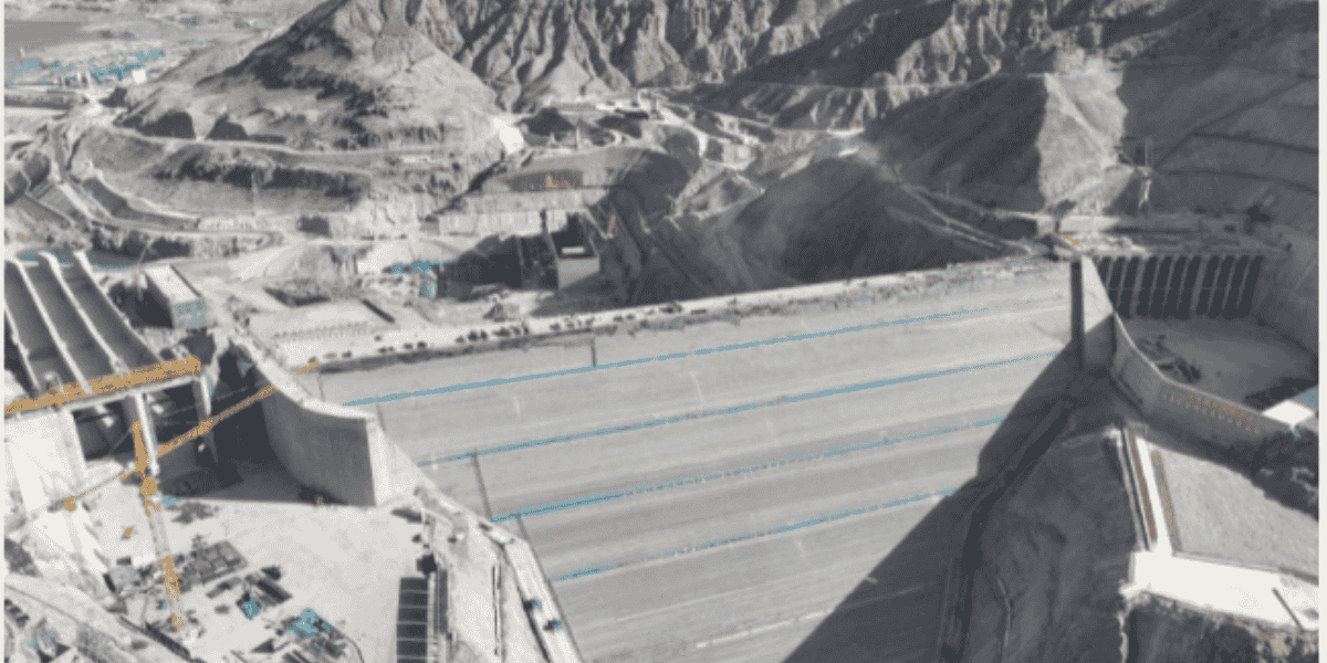
China is proceeding with the construction of massive hydropower dams on the upper reaches of the Machu (Yellow River) in Tibet despite mounting scientific concerns about potential geological disasters and severe environmental consequences.
A recent report by Turquoise Roof, a collaborative research network focused on Tibet, has raised alarms over these large-scale infrastructure projects.
For the first time, China is building hydropower dams upstream in Tibet, targeting the sources of Asia’s major rivers. The report highlights the construction of at least three significant dams on the upper Machu River.
The Machu River, known as the Huang He in Chinese, is also known as the “Sorrow of China” because of the devastating floods it has caused.
This region, already seismically unstable and heavily impacted by climate change, poses substantial risks, yet China continues its dam-building efforts in this delicate environment.
The Yellow River’s Significance
The Yellow River, or Machu River in Tibet, is a vital waterway that spans northern China. Known as the “Mother River” in China, it is the second-longest river in China and the sixth-longest river system globally.

Tibetan Autonomous Prefecture, Qinghai. Photo: China News.
The Yellow River, often referred to as the “world’s muddiest river,” is notorious for its high sediment content. This heavy sediment buildup has earned it another nickname, the “hanging river,” as the accumulated silt raises riverbed sections above the surrounding landscape. Over time, this accumulation has caused the river to change its course, resulting in frequent and devastating floods.
Over a third of the river’s course lies in Tibet, where it flows nearly 2,000 kilometers across the Amdo region in northern Tibet. Originating on ‘the Bayan Har Mountains’ – the Tibet-Qinghai Plateau (15,000 feet), the Yellow River runs eastward through seven Chinese provinces: Qinghai, Gansu, Ningxia, Inner Mongolia, Shaanxi, Shanxi, Henan, and Shandong, before emptying into the Bo Hai Gulf in the Yellow Sea.
The Yellow River comprises three distinct sections: the upper course through mountainous terrain, the middle course across a plateau, and the lower course flowing through a low plain.
The combination of its massive sediment load and unpredictable course makes the Yellow River both a crucial waterway and an environmental hazard.
Why Are Hydropower Dams In The Upstream Of Rivers Dangerous?
Climate Change: Chinese scientists warn that the combined effects of intense human activity and adverse climate change have led to significant ecological and environmental problems in the upper reaches of the Yellow River. These issues have jeopardized the region’s ecological security and power supply.
Building a series of dams, or a cascade, requires raising captive water levels high enough to reach the bottom of the next dam upriver. This transforms a once fast-moving mountain river into a series of man-made lakes, each tightly positioned against its upstream neighbor.
To achieve this, dams must be among the world’s tallest, standing 300 to 400 meters high. If one dam fails, a catastrophic chain reaction could potentially trigger the collapse of successive dams, much like a tsunami of water.
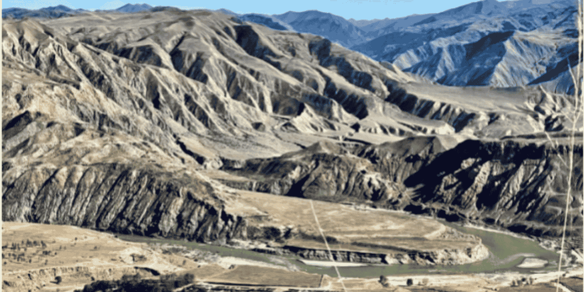
Danger To The Permafrost Zone: Building dams at high altitudes in Tibet presents another risk: thawing permafrost. Tibet’s permafrost zone is the largest outside the Arctic, and construction on this unstable ground presents a significant challenge. As the permafrost thaws each summer and freezes again in winter, the shifting subsoil may threaten the dam’s stability.

located at a bend of Machu river in the Amdo region of the Tibetan plateau. Photo obtained in April 2022, from
Tibet Watch.
Additionally, as permafrost melts across 1.6 million square kilometers of the Tibetan plateau, methane—much more potent than carbon dioxide as a greenhouse gas—is released into the atmosphere. China has no clear policies or measures in place to address these methane emissions, exacerbating climate change.
Coal-Fired Power Plants: While China positions itself as a leader in clean energy, it is still the world’s largest emitter of greenhouse gases. In the first half of 2024, China led the globe in constructing new coal-fired power plants.
Despite the presence of renewable energy sources, the report shows that coal-fired power plants dominate the region’s power grid, highlighting China’s continued reliance on fossil fuels. This reliance contradicts its claims of aggressive decarbonization.
While hydropower is considered renewable, large-scale hydropower projects have significant environmental and social consequences, including disruption of ecosystems and displacement of communities. China’s strategy of combining hydropower with coal power may be a way to present a cleaner energy profile without addressing the deeper ecological impacts.
Devastation Of Local Communities: The impact on local Tibetan communities has been severe. According to the report, The Yangkhil (Yangqu) hydropower station, the first major dam built upriver on the Machu, has destroyed an entire Tibetan community. Eyewitness accounts detail the forced dismantling of homes and the destruction of a monastery, which was removed from the protected heritage list before demolition.
While Chinese engineers boast about using AI-driven robots in construction, these technological advancements come at a high human cost.
The report also highlights that in February, Tibetans risked their lives to protest the Kamtok (Chinese: Gangtuo) dam being built on the upper Drichu (Yangtze) River. The dam directly threatens their homes and six historic monasteries, which house priceless 14th-century frescoes that Chinese scholars have long sought to preserve.
Tibet’s Rivers Under Siege
Before this, In January 2023, satellite images confirmed that China was constructing a new dam on the Mabja Zangbo River in Tibet, a tributary of the Indian Ganga River.
This river lies near the tri-junction of India, Nepal, and Tibet. Construction of the dam, which began in May 2021, is located approximately 16 km north of this tri-junction, opposite Uttarakhand’s Kalapani territory.
This development has raised significant concerns for downriver nations, India and Nepal, especially as China has been increasing its military and dual-use infrastructure along both the eastern and western sectors of the Line of Actual Control (LAC).
As highlighted by the Turquoise Roof report, China’s hydropower projects upstream of the Yellow River also have significant downstream impacts, affecting farmers and fisherfolk in countries like Cambodia, Vietnam, Thailand, Laos, and Myanmar.
The far-reaching consequences of these projects underscore the risks of unchecked infrastructure development in ecologically sensitive regions.
This aggressive dam construction in Tibet’s fragile ecosystem represents a significant shift in China’s infrastructure development strategy, raising serious concerns about long-term environmental sustainability and regional stability.
- Shubhangi Palve is a defense and aerospace journalist. Before joining the EurAsian Times, she worked for ET Prime. In this capacity, she focused on covering defense strategies and the defense sector from a financial perspective. She offers over 15 years of extensive experience in the media industry, spanning print, electronic, and online domains.
- Contact the author at shubhapalve (at) gmail.com


